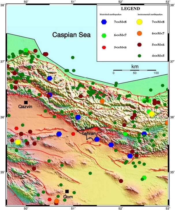
[By Shideh] I read an interesting article by H. Hamzehloo, F. Vaccari, and G.F. Panza, “ Towards a reliable seismic microzonation in Tehran, Iran,” a few parts of which I am including below:
“Tehran, the capital of Iran, is located in a very high seismic zone at the foot of the Alborz Mountains, which is part of the Alpine-Himalayan seismic belt. The distribution of historical earthquakes around Tehran shows that the region has been experiencing eight large destructive earthquakes with magnitude greater than 7 from 4th B.C to 1830 (Ambraseys and Melville, 1982). These large historical earthquakes caused severe damage to Shahre Ray City, which is a part of Tehran city at present. The last large historical event was the 1830 earthquake with magnitude 7.1, which occurred approximately 100 km from the city. The closest historical event to the city was the 855 earthquake with magnitude 7.1.
Different investigators have studied the microzonation of Tehran (e.g., Japan International Cooperation Agency (JICA), 2000, [Jafari, 2002] and [Haghshenas, 2005]). The urban area of Tehran has been developed on alluvial layers, accumulated on hard rock. The uppermost geological formation basically represents the distribution of the Pliocene and Quaternary alluvial and glacial deposits in the Tehran region.”
What caught my attention the most (in the context of this blog) is the amplification pattern in ground motions due to Tehran’s particular geology and the abundance of bedrock at shallow depths. I have personally heard from local engineers in Tehran and other cities (more than once) that, “there is no need to worry about earthquakes at this location; the bedrock is only a couple of meters deep.” Well, frankly, rocks amplify the ground motion more than soils, and they affect the motion (and the structures) in different ways. It is true that they have better strength and don’t cause many of the problems that soils create. However, everything really depends on your building, the foundation, and the properties of the rock, and making hasty judgment on whether the presence of bedrock is going to help during an earthquake or not, is a sign of ignorance. So, be aware!
The most important earthquakes around Tehran
| Date | Long. | Lateral | Magnitude | Distance to the city (km) |
| 4th BC | 51.8 | 35.5 | 7.6 | 50.0 |
| 743 | 52.2 | 35.3 | 7.2 | 94.0 |
| 855 | 51.5 | 35.6 | 7.1 | 25.0 |
| January 864 | 51 | 35.7 | 5.3 | 31.0 |
| 23/2/958 | 51.1 | 36 | 7.7 | 32.0 |
| 10/12/1119 | 49.9 | 35.7 | 6.5 | 129.0 |
| May 1177 | 50.7 | 35.7 | 7.2 | 57.7 |
| 15/8/1485 | 50.5 | 36.7 | 7.2 | 126.0 |
| 1495 | 50.5 | 34.5 | 5.9 | 160.7 |
| 20/4/1608 | 50.5 | 36.4 | 7.6 | 102.0 |
| 1665 | 52.1 | 35.7 | 6.5 | 69.0 |
| 3/2/1678 | 50 | 37.2 | 6.5 | 198.0 |
| 1678 | 52.6 | 36.3 | 6.5 | 127.0 |
| 16/12/1808 | 50.3 | 36.4 | 5.9 | 115.0 |
| 1809 | 52.5 | 36.3 | 6.5 | 120.0 |
| 1825 | 52.6 | 36.1 | 6.7 | 119.0 |
| 27/3/1830 | 52.5 | 35.7 | 7.1 | 105.0 |
| 1/8/1868 | 52.5 | 34.9 | 6.4 | 143.0 |
| 20/10/1876 | 49.8 | 35.8 | 5.7 | 138.0 |
| 1/9/1962 | 49.81 | 35.71 | 7.2 | 137.0 |
| 20/6/1990 | 49.41 | 36.96 | 7.4 | 225 |
| 22/6/2002 | 48.94 | 35.85 | 6.5 | 220.0 |
| 28/5/2004 | 51.61 | 36.29 | 6.3 | 61.0 |

From our Iran trip, I recall someone talking about a large microzonation project currently underway. Was it the IIEES? Is the paper you reference part of that effort?
I’m not sure. The primary author of this paper is affiliated with the IIEES (the International Institute of Earthquake Engineering and Seismology, Tehran, I. R. Iran). This is a study towards a more reliable seismic microzontation for Tehran, but I’m not sure if this team is working toward further research (which is needed) and its implementation.
can someone explain what seismic microzonation means?
Dear Mehdi,
Seismic microzonation, as I understand it, is the process of estimating the soil response under earthquake excitation, taking into account local site effects in your zone of interest. This means considering seismological, geological, and geotechnical characteristics of your specific site to be able to evaluate the ground motion characteristics (like earthquake PGA or spectral values) on the ground surface. This is a required step to be able to do proper seismic analysis for a project, and a critical part of earthquake hazard evaluation and mitigation in urban regions. Let me know if you need more info.
When is it going to be a earth quick in Tehran?is there any way to stope that?
Your site is really interesting to me and your subject matter is very relevant. I was browsing around and came across something you might find interesting. I was guilty of 3 of them with my sites. “99% of website managers are guilty of these 5 HUGE errors”. http://tinyurl.com/cuyfkfj You will be suprised how fast they are to fix.
My nigger
Not sure about this text. It seems to be all right, but something is missing